
- Six places appear in all four published itineraries. Sao Bento, Lello, Clerigos, the cathedral, Ribeira and Gaia.
- That whole day is 3.1 km and 41 minutes of walking. Far less than it sounds.
- But it descends 148 metres. The distance is not what tires you in Porto.
- Walked in reverse it climbs those same 148. Identical route, 77 metres of net difference.
- The worst stretch is the cathedral down to the river: 73 metres of drop in 554 metres of walking.
- None of the four itineraries publishes any of this. One mentions a distance; nobody mentions the climb.
Day one on foot
3.1 km
Walking time
41 minutes
Downhill
148 m
Uphill
71 m
Reversed
the two swap
Highest point
Lello, 92.5 m
Lowest
Ribeira, 1 m
Every itinerary for Porto lists more or less the same places in more or less the same order, and not one of them tells you the only thing that is genuinely hard to guess: how much of the day is uphill. Porto is built on the side of a gorge. The difference between a pleasant morning and a brutal one is not which sights you pick, it is which way round you walk them.
So we took the day that four published itineraries agree on and measured it, along real pedestrian routes with real elevation.
The six places all four agree on
Reading four itineraries that rank for this search and counting what each one includes, six places appear in every single one:
| Place | In how many itineraries |
|---|---|
| Sao Bento station | 4 of 4 |
| Clerigos tower | 4 of 4 |
| The cathedral | 4 of 4 |
| Ribeira | 4 of 4 |
| Dom Luis I bridge | 4 of 4 |
| Vila Nova de Gaia | 4 of 4 |
| Mercado do Bolhao | 3 of 4 |
| Foz do Douro | 3 of 4 |
| Cafe Majestic | 3 of 4 |
| Livraria Lello | 2 of 4 |
| Douro valley | 2 of 4 |
| Serra do Pilar | 2 of 4 |
| Palacio da Bolsa | 1 of 4 |
Four itineraries read in full on 28 September 2026. Three more in the top ten could not be retrieved.
Those 6 are the first day, in every version of it. Livraria Lello only appears in two of the four, which is surprising for the city's most famous interior, and the reason is probably that it now needs a timed ticket. It is on the route regardless, and we costed it in the guide to Livraria Lello.
It is 3.1 km, which is less than it feels
Routed along pedestrian ways from the Avenida dos Aliados to the Gaia quay, taking in all six and passing the Clerigos tower on the way, the whole day comes to 3.1 km and about 41 minutes of walking.
Forty one minutes. That is the entire first day of a Porto itinerary, on the clock, moving. Everything else is time spent inside places, eating, queueing or standing still looking at the river. If you were worried about whether three days is enough to see Porto on foot, the distance is not the constraint.
The climb, which is the real number
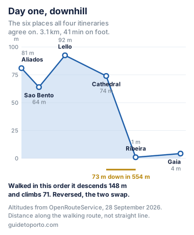
From 81 metres at the Aliados to 1 metre at the Ribeira quay. The highest point of the day is Livraria Lello at 92.5 m and the lowest is the river, which gives a range of 91.5 metres inside a 3.1 km walk.
Walked in the standard order, the day descends 148 metres and climbs 71. That is the good version. It is also the version nobody tells you to choose, because nobody mentions the hill at all.
Walking it backwards costs you 148 metres
Here is the whole point of measuring it. The same six places, the same 3.1 km, in the opposite order:
| Direction | Distance | Climb | Descent | Net |
|---|---|---|---|---|
| Aliados to Gaia | 3.1 km | 71 m | 148 m | 77 m down |
| Gaia back to Aliados | 3.1 km | 148 m | 71 m | 77 m up |
Same route, measured in both directions on 28 September 2026.
Twice the climb for exactly the same sights. The decision costs nothing, takes no planning and is invisible in every itinerary we read, which list the places in an order without ever saying that the order is the point.
The seven stretches, one by one
| Stretch | Distance | On foot | Up | Down |
|---|---|---|---|---|
| Aliados to Sao Bento | 330 m | 4 min | 0 m | 17 m |
| Sao Bento to Livraria Lello | 490 m | 5.9 min | 28 m | 0 m |
| Lello to the cathedral | 775 m | 9.3 min | 17 m | 36 m |
| Cathedral down to Ribeira | 554 m | 6.7 min | 11 m | 84 m |
| Ribeira across to Gaia | 845 m | 14.3 min | 13 m | 10 m |
| Gaia up to Serra do Pilar | 1150 m | 13.8 min | 71 m | 22 m |
| Ribeira back up to Aliados | 1014 m | 12.2 min | 82 m | 2 m |
The first five are the consensus day. The last two are common additions: the viewpoint above Gaia and the walk back up to the centre.
The cathedral down to the Ribeira is the stretch that defines the day: 73 metres of net drop in 554 metres of walking, which is a gradient of about 13 per cent averaged over the whole stretch and steeper in places, much of it on steps.
The two additions are worth their own line. Serra do Pilar climbs 71 m from the Gaia quay, which is why the view from it is the one on the postcards, and it is the single biggest climb anywhere near the standard route. And walking back up from the Ribeira to the Aliados is 80 metres in a kilometre. That is the one that catches people at the end of the day, and it is the one the funicular and the bridge's upper deck exist to avoid.
Where you sleep decides the direction
You cannot choose the direction freely if your hotel is at the bottom. Sleeping in the Ribeira or on the Gaia quay means the day ends with the climb, every day, and no amount of planning fixes it.
That is measured properly in the guide to where to stay in Porto, which found that the flat options are Aliados, Boavista and Foz, and that Ribeira is flat only once you are down there. If anyone in the group has limited mobility, the choice of neighbourhood matters more than the choice of route.
There is also a way to skip part of it. The crossing to the Gaia cellars can be done on either deck of the Dom Luis bridge, and which deck you take changes the climb by about 70 metres.
Days two and three
There is no consensus to report after day one, and that is worth saying rather than inventing one. The four itineraries diverge completely.
What they partly share: two of the four give a full day to the Douro valley, which is not a day in Porto at all but a ten hour trip out of it, and we compared those tours on price and evidence in the guide to Douro valley tours. Three of the four include Foz and the coast, which is inside the metro network and covered in the guide to the beaches.
Beyond that, what fills the other two days is preference, and everything that appears on any of the lists is costed in the things to do in Porto page, where five of the eleven most recommended things turn out to be free.
What this page does not tell you
This is not our itinerary. Nobody here walked this route with a stopwatch; it is the route four other people published, measured on a map with elevation data. Specifically:
- No time inside anywhere. The 41 minutes is walking between places and nothing else. Lello, the cathedral and a cellar visit are hours, not minutes, and they are what actually fills the day.
- Cumulative ascent exaggerates in cities. Elevation models count every small undulation, so the 148 m figure is an upper bound. That is why the net change between endpoints, 77 m, is published next to it every time.
- No surfaces and no steps counted. Much of the descent to the river is on stairs and worn stone, which is not the same as 73 metres of ramp, and we have not measured that.
- No day two or day three route, because the four sources do not agree on one and we are not going to invent the consensus.
How this was measured
Four itineraries ranking for this search were read in full on 28 September 2026 and each was checked for every place mentioned, which produced the consensus count. Three further results in the top ten returned errors and are not included.
The route was then measured with OpenRouteService on the walking profile with 3D geometry, joining the six consensus places in the published order. Distances follow pedestrian ways rather than straight lines, and altitudes come from the elevation model at each point of the returned geometry, which had 223 points for the full day.
One honest caveat, and it applies to every figure with the word climb in it. Cumulative ascent sums every rise along the route including tiny undulations in the terrain model, and in a dense city that inflates the total. Every ascent figure here is published alongside the net height change between the two endpoints, which is measured from the 3D geometry and is not affected.
Questions
Is three days enough for Porto?
On the walking, comfortably. The first day that all four published itineraries agree on covers six places in 3.1 km and 41 minutes of actual walking, which is a short morning. What fills three days is not distance but the time inside each place and the climbs between them, and the city is small enough that nothing on the standard route is far from anything else.
How far do you walk on a day in Porto?
The standard first day, from the Aliados down through Sao Bento, Livraria Lello, the cathedral and Ribeira and across the bridge to Gaia, is 3.1 km and about 41 minutes of walking measured along the pedestrian route. That is less than most people expect. The tiring part is the 148 metres of descent, or of climb if you walk it the other way.
Is Porto very hilly to walk?
Yes, and it is the thing the itineraries do not tell you. The standard first day drops from 81 m at the Aliados to 1 m at the Ribeira quay, and the worst stretch is the cathedral down to the river: 73 metres of descent in 554 metres of walking. The highest point of the day is Livraria Lello at 92.5 m and the lowest is the Ribeira at 1 m, a range of 91.5 metres inside a three kilometre walk.
Which direction should you walk the Porto itinerary?
Downhill, which means starting at the Aliados and ending at the river or in Gaia. Walked in that order the day descends 148 m and climbs 71. Walked in reverse it is exactly the same 3.1 km but climbs 148 and descends 71, so the direction is worth 77 metres of net climb and it is entirely free to choose.
What should you do on day two and day three in Porto?
The four itineraries diverge after the first day, so there is no consensus to report. Two of the four give a full day to the Douro valley, which is a ten hour trip out of the city rather than a day in it. Foz and the coast appear in three of the four, and they are inside the metro network. Beyond that it is preference, and this page does not pretend otherwise.
How accurate are these distances?
They are routed along actual pedestrian ways rather than measured in straight lines, using OpenRouteService with 3D geometry on 28 September 2026. One caveat is stated on the page: cumulative ascent from elevation models exaggerates in cities because it counts every small undulation, so every figure here is published alongside the net height change between the start and end points, which is not subject to that problem.
Header photograph: Livraria Lello bookshelves (51489653925) by Scott Edmunds, licensed under CC BY 2.0. Cropped to fit.
Written by Diego Fresno, This is not my itinerary. I read four that rank for this search, counted what they agree on, and found six places that appear in all of them, which is the first day in every version. Then I measured that day properly: routed along real pedestrian ways with elevation data. It comes to 3.1 km and 41 minutes of walking, which is far less than the phrase "day one of a Porto itinerary" suggests, and it drops 148 metres. Walk the identical route in the opposite order and you climb those 148 instead. That choice is free, takes no planning, and not one of the four mentions it. Verified quarterly: last review September 2026. About the author →